
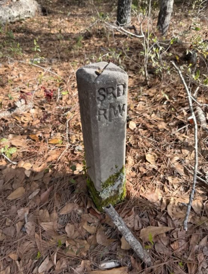
At first glance, there doesn’t seem to be anything particularly unusual about this woodland scene.
There are trees, fallen leaves, pine needles, a few scattered branches, and what appears to be a quiet path running through the area. But standing just off the path is a small concrete post that immediately catches the eye.
It looks old.
Its surface is weathered and covered with dirt and moss near the bottom. The edges have softened with age, and the surrounding vegetation suggests that nobody has paid much attention to it for quite some time.
But then you notice the letters carved into the front:
SPR
And beneath them:
RW
Suddenly, the ordinary-looking piece of concrete becomes a mystery.
What is it?
Why was it placed there?
Who put it in the ground?
And perhaps most importantly, what does “RW” mean?
The answer is probably much less mysterious than it first appears, but it tells an interesting story about how land boundaries and transportation corridors have been marked for generations.
The Strange Concrete Marker
The object in the photograph isn’t a random piece of broken concrete.
Its shape is too deliberate.
It is tall and narrow, with a rounded or slightly sloped top. It has been firmly set into the ground rather than simply dropped there. Most importantly, letters have been intentionally carved into its face.
That is a major clue.
When you encounter an isolated concrete monument like this in a wooded area, especially one bearing abbreviations, it is often connected to surveying, property boundaries, transportation corridors, or rights-of-way.
The marker isn’t necessarily there to tell hikers where to go.
It may be marking something much less obvious beneath the surface: an invisible legal boundary.
So What Does “RW” Mean?
The two letters beneath the larger marking are the biggest clue.
RW commonly means “right-of-way.”
A right-of-way is a legally established corridor or strip of land associated with the right to pass through, use, maintain, or access property for a particular purpose.
Government agencies, transportation authorities, utilities, railroads, and other organizations can have rights-of-way.
These areas can be much wider than the road, trail, or infrastructure that you can actually see.
That’s why a marker like this might appear surprisingly far away from anything that looks like a road or railroad.
The visible path isn’t necessarily the boundary being marked.
The marker could be identifying the edge of a larger corridor.
Official transportation documents commonly use R/W or RW as an abbreviation for “right-of-way,” and concrete right-of-way markers are specifically used to identify such limits.
What Does “SPR” Mean?
This part is more difficult to determine from the photograph alone.
The letters SPR could refer to an organization, railroad, transportation entity, project, or other designation associated with the right-of-way.
Without knowing exactly where this marker is located, it would be risky to claim that “SPR” definitely refers to one particular railroad or agency.
That’s an important distinction.
Old survey and right-of-way markers can use abbreviations that make perfect sense to the people who installed them but are almost impossible for a modern passerby to decode without a map or local records.
So the safest interpretation is:
SPR RW likely identifies a particular right-of-way associated with the entity or system represented by “SPR.”
The “RW” portion is the strongest clue because right-of-way markers are a well-established type of land marker.
Why Would a Marker Be Sitting in the Woods?
This is probably the part that makes the photograph so interesting.
If this is a right-of-way marker, why isn’t it beside a road?
Why is it surrounded by trees and leaves?
The answer is that rights-of-way don’t always look like roads.
A right-of-way is fundamentally a legal and surveyed area.
The physical infrastructure using that area might have changed, disappeared, or been relocated over the years.
A road could have been abandoned.
A railroad could have been removed.
A utility corridor could have changed.
A trail could have been created later.
But the legal boundary—or evidence of where that boundary once existed—can remain.
The concrete monument can therefore survive long after the feature that originally made the boundary important has faded from everyday memory.
The Forest Can Hide History
This is one of the fascinating things about walking through older wooded areas.
Nature doesn’t erase history completely.
It covers it.
Leaves accumulate.
Moss grows.
Branches fall.
Trees mature.
Paths become overgrown.
Eventually, something that was once obvious can become almost invisible.
A person walking past this marker today might simply assume it’s an old concrete post.
But decades earlier, it may have been an important reference point for surveyors, engineers, railroad workers, landowners, or maintenance crews.
The forest doesn’t necessarily tell you what the object was used for.
You have to read the clues.
And in this case, the letters are the biggest clue of all.
Right-of-Way Markers Are More Important Than They Look
A right-of-way boundary may sound like a boring legal technicality, but it can have very real consequences.
Imagine a railroad passing through an area.
The railroad doesn’t simply occupy the few inches of land directly beneath the rails.
There can be a much wider corridor associated with the railway.
That corridor can include space needed for maintenance, drainage, access, safety, and other purposes.
Similarly, a road’s right-of-way can extend beyond the pavement.
This is why you sometimes see survey markers, utility poles, drainage structures, fences, or other infrastructure sitting surprisingly far from the visible road.
The road is only one part of the overall corridor.
A Marker Doesn’t Necessarily Mean There’s Something Buried Beneath It
When people discover old concrete monuments, they sometimes wonder whether the marker is covering something important.
In many cases, the marker itself is the important object.
It provides a fixed physical reference point.
Surveyors can use known monuments to establish or verify boundaries and measurements.
Modern surveying often uses sophisticated equipment and precise coordinates, but physical monuments remain useful as reference evidence.
In some jurisdictions, concrete monuments are specifically used to mark right-of-way limits or other surveyed locations.
So there doesn’t have to be a hidden box, tunnel, treasure, or artifact underneath the post.
Its purpose may simply be to say:
This location matters.
Why Is It So Tall?
The marker in the photograph is noticeably taller than a simple stake.
That’s useful because a marker needs to remain visible enough to be located again.
Imagine trying to find a small metal pin hidden beneath several inches of leaves.
It would be incredibly easy to miss.
A larger concrete monument is much easier to locate.
Even after vegetation grows around it, the top can remain visible.
And if the surrounding landscape changes, a durable marker can remain in place for many years.
That durability is one reason concrete has historically been useful for permanent survey monuments.
The Weathering Tells a Story
Look closely at the marker.
The lower portion is surrounded by moss and vegetation.
The concrete has darkened.
The edges are no longer perfectly crisp.
The carved letters remain visible despite years of exposure.
That suggests the marker has been sitting there for quite some time.
Of course, a photograph alone can’t tell us exactly when it was installed.
But its weathered condition is another reminder that the object may predate the modern appearance of the surrounding path.
It is entirely possible that people have been walking nearby for years without paying any attention to it.
Could the Path Be Older Than It Looks?
Possibly—but the marker itself doesn’t prove that.
This is where it’s important not to confuse clues with certainty.
The presence of a right-of-way monument doesn’t necessarily mean the current path follows the original route of whatever the marker represents.
The path could be modern.
It could be a hiking trail.
It could be a maintenance route.
It could even follow a completely different boundary.
The marker tells us that someone considered that particular location important enough to mark.
The exact relationship between the marker and the current path would require local records or a survey map to determine.
The Most Interesting Part May Be What You Can’t See
The photograph shows a concrete marker.
But what makes it interesting is the invisible line it may represent.
Imagine drawing a line from this marker to another marker somewhere farther down the trail.
Then another.
And another.
Suddenly, a seemingly ordinary patch of forest may contain a carefully surveyed boundary.
You wouldn’t see the line.
There might be no fence.
No painted stripe.
No sign.
Just a series of monuments quietly defining something important.
That’s one of the strange things about property boundaries.
They’re often invisible until you know what you’re looking for.
Why Old Markers Survive for Decades
A marker like this has an advantage over many modern signs.
It doesn’t depend on paint remaining bright.
It doesn’t require electricity.
It doesn’t need a digital connection.
It simply sits there.
Rain can fall on it.
Snow can cover it.
Leaves can pile around it.
Branches can grow beside it.
The inscription can weather slowly.
But the marker can remain.
That’s why old concrete survey monuments can sometimes provide fascinating glimpses into the history of a landscape.
They are physical records.
Don’t Move It
If you ever encounter a marker like this while hiking or exploring, one of the most important things you can do is leave it exactly where you found it.
A survey monument isn’t necessarily just an old piece of concrete.
It can have legal or surveying significance.
Moving, damaging, or removing a boundary monument can create serious problems, particularly if it is still recognized as an official marker.
Even if it appears abandoned, it’s better to photograph it and leave it alone.
If you’re genuinely curious about its meaning, local land records, transportation agencies, survey records, or historical maps may provide the answer.
The Mystery of the Missing Infrastructure
One particularly interesting possibility is that the marker may outlast whatever originally surrounded it.
History is full of infrastructure that disappears.
Old rail lines become walking trails.
Roads are abandoned.
Bridges are removed.
Utility routes are relocated.
Property is divided.
Names change.
Organizations disappear.
But a concrete monument can remain in the soil.
That’s how an object with an ordinary purpose can eventually become mysterious.
The people who installed it knew exactly what it meant.
The people who encountered it a generation later may have had only a vague idea.
Eventually, someone takes a photograph and asks:
“What’s this thing?”
Why These Discoveries Fascinate Us
There is something satisfying about finding an object that doesn’t immediately make sense.
A modern sign explains itself.
A mailbox looks like a mailbox.
A road sign tells you what it means.
But an old concrete marker surrounded by trees gives you almost no context.
It forces you to investigate.
The letters become clues.
The shape becomes a clue.
Its location becomes a clue.
The surrounding landscape becomes another clue.
And gradually, a story begins to emerge.
That’s why seemingly ordinary objects can become fascinating pieces of local history.
What the Photograph Can Tell Us
From the photograph alone, several observations are reasonable:
- It is a deliberately manufactured concrete monument.
- It is firmly positioned in the ground.
- It carries an inscription.
- The visible inscription includes “SPR” and “RW.”
- The marker is located in a wooded environment beside a path.
- The surrounding vegetation and weathering suggest that it has been there for some time.
- “RW” is commonly used to mean “right-of-way.”
What we cannot establish from the photograph alone is exactly what “SPR” refers to, the precise date the monument was installed, or the exact boundary it marks.
Those details would require additional location information or historical/survey records.
And that’s actually part of what makes the image intriguing.
There are enough clues to make an educated interpretation, but not enough information to tell the entire story with certainty.
A Small Monument With a Bigger Story
Imagine the landscape decades ago.
The trees may have been smaller.
The path may have looked different.
The property may have had another owner.
The surrounding land may have been used for an entirely different purpose.
Someone carrying surveying equipment could have stood exactly where the photographer is standing today.
They might have measured distances, checked a boundary, installed the concrete monument, recorded its position, and moved on.
The marker remained.
The people involved eventually disappeared.
The landscape changed.
But their work left behind this small piece of concrete.
The Answer Isn’t Hidden in the Forest—It’s in the Letters
At first, the surrounding woodland is the mystery.
But once you notice the inscription, the photograph becomes much easier to understand.
RW is the giveaway.
Rather than being a random decoration or meaningless carving, it likely indicates a right-of-way.
The remaining letters, SPR, probably identify the organization, route, property, or system associated with that right-of-way.
Without a location, however, it would be speculation to assign those initials to a particular company or railroad.
So the real mystery isn’t necessarily “What is this?”
It’s:
“Whose right-of-way was this, and why was it important enough to mark here?”
That’s the question that local history could potentially answer.
Conclusion :
So, what’s hiding beside this path?
Not a buried treasure.
Not a mysterious machine.
And probably not anything dangerous.
The object in the photograph appears to be an old concrete survey or right-of-way marker, with the letters “RW” providing the strongest clue to its purpose. Right-of-way markers are used to identify boundaries or limits associated with roads, railways, utilities, and other corridors, and concrete monuments can remain in place for decades.
The “SPR” inscription likely provides an additional identification, but without knowing the exact location, it would be impossible to say confidently which organization or system those initials represent.
And perhaps that’s the most interesting part.
The marker is a tiny piece of evidence from a much larger story.
Somewhere beneath the leaves and trees may be an old boundary line that most people would never notice. The road, railway, property, or infrastructure connected to it may have changed dramatically—or disappeared altogether.
Yet this little concrete monument remains.
Quietly standing beside the path.
Weathered by rain and surrounded by moss.
Waiting for someone curious enough to stop and ask what it means.
Sometimes the most interesting things hiding in plain sight aren’t spectacular at all.
They’re ordinary objects carrying traces of a history that the landscape has almost forgotten.